Kelvin Waves in California: What They Are and What They Mean for Surf Fishing
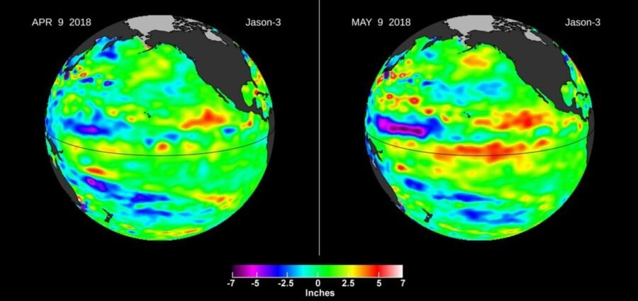
In early October, a Kelvin wave did something most anglers had never seen. The tide gauge at San Diego read 18 inches above the predicted tide. Water flooded the Redondo Beach boardwalk. Long Beach evacuated homes after Tropical Storm Rachel pushed waves into them. Tide levels in San Diego topped 8 feet, among the highest in more than a century.
The cause was not a storm surge, and it was not the tide itself. It was a Kelvin wave, a slow bulge of warm water that traveled thousands of miles across the Pacific and then ran up the California coast. One had already arrived. Three or four more are expected before this El Niño ends.
Most surf anglers have never heard of a Kelvin wave. If you fish the California coast this winter, you should know what it is, because it is going to change the water you fish in.
What Is a Kelvin Wave?
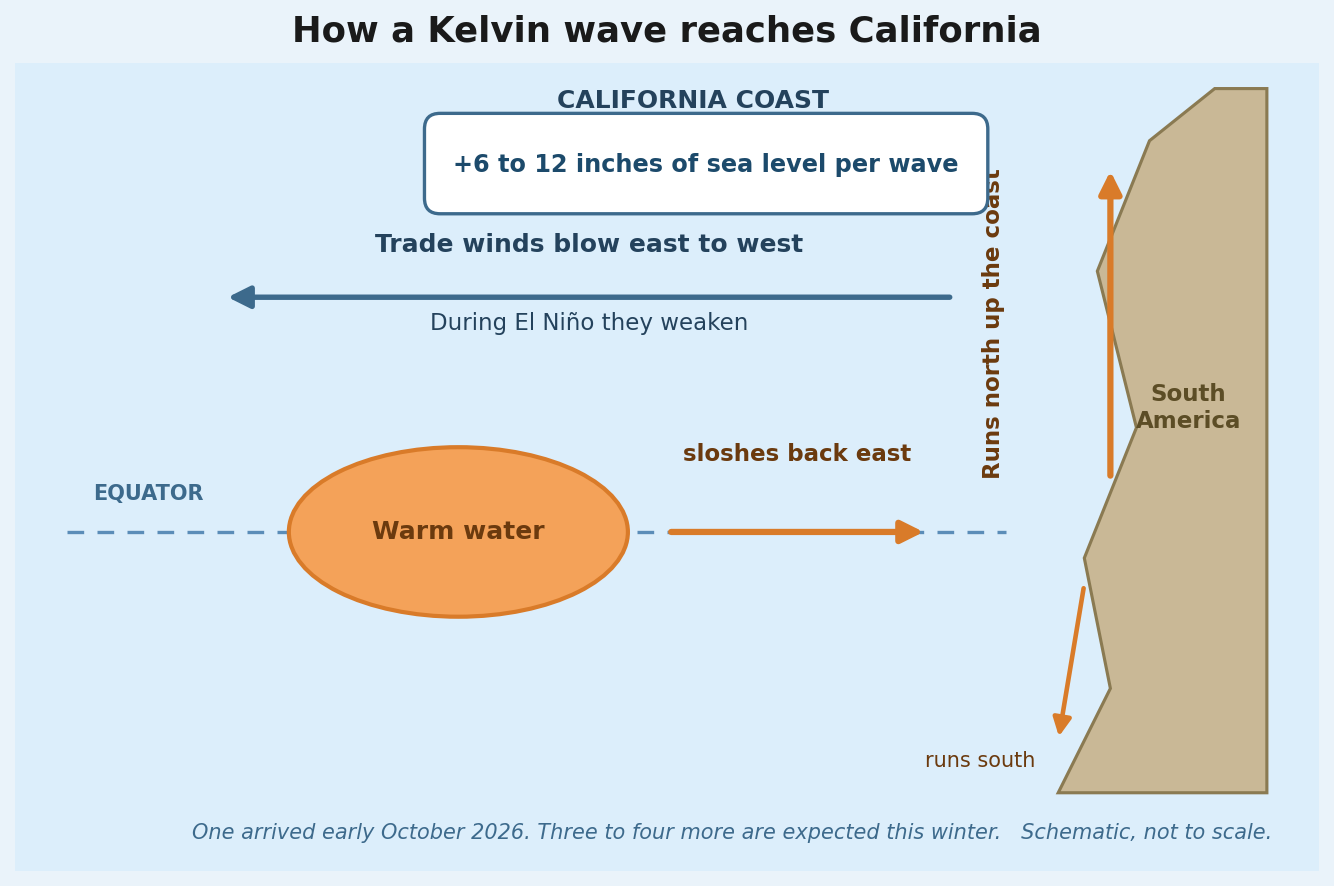
A Kelvin wave is a bulge of warm water that moves slowly across the ocean. It starts at the equator, where the trade winds normally blow from east to west and push warm surface water toward Indonesia. During an El Niño, those trade winds weaken. Without the wind holding it back, the warm water sloshes back east across the Pacific.
When that bulge of water reaches South America, it splits. One part turns north and runs up the coast of the Americas. One part turns south. The part that comes north travels up the coast of Mexico and California, raising sea level as it goes.
A few things worth knowing about how they work:
They move slowly. A Kelvin wave takes weeks to cross the Pacific and more weeks to travel up the coast. It is not a wave you see break on the beach. It travels underwater, stretching over very long distances, and it changes sea level only slightly as it passes.
Each one raises sea level 6 to 12 inches. That does not sound like much, but it stacks on top of everything else. On top of the normal tide. On top of king tides. On top of the extra water height from warm water expanding, which is already adding 6 to 10 inches off our coast.
They bring warm water with them. Each Kelvin wave carries warm water from the tropical Pacific up the coast. Every time one arrives, it warms our water a little more and strengthens the marine heatwave that has been sitting off California since May 2025.
Why This El Niño Is Different
Kelvin waves happen during every El Niño. This one is producing bigger ones because the El Niño itself is historic.
NOAA has had an El Niño Advisory in effect since June 11th, 2026. The weekly Niño-3.4 reading, the key measurement of how warm the equatorial Pacific is, hit 3.4 degrees Celsius above normal in late October. The official three month index for August through October is 2.5 degrees above normal. NOAA puts the chance that October through December becomes the strongest El Niño since 1950 at 83 percent.
The peak is happening right now, November to December, and the event is expected to stay strong through January to March 2027.
The Kelvin wave that arrived in early October was the first of the season. According to NOAA oceanographer Michael Jacox, one or two more were already crossing the tropics behind it. The Union of Concerned Scientists expects three to four total to run up the coast before this El Niño ends.
What It Means for Sea Level This Winter
Add up the pieces and the picture is striking.
The marine heatwave off Baja and Southern California, a Category 4 extreme event, has been adding 6 to 10 inches of water height through thermal expansion. The Kelvin wave in early October added another 6 to 12 inches. The National Weather Service in San Diego expects base sea levels to stay 1 to 2 feet higher than last winter all season long.
Now put the king tides on top of that. The highest tides of the year arrive November 24th through 26th, peaking on the 25th, then December 23rd through 25th, peaking on Christmas Eve, then January 21st through 22nd. I covered the full king tide schedule and what it means for fishing here.
High tides are going to push further up the beach than most anglers are used to. Low tides will expose structure that is normally underwater. If you fish a beach with a steep profile or a seawall, your access at high tide may disappear entirely. If you fish a flat beach, the troughs you know will fill differently.
Check the tide chart before every session this winter, not just the surf height. My forecast tool tracks tides for all 58 beaches.
What It Means for Surf Fishing
Here is the part that matters for the fishing itself.
The water is staying warm. Buoys off San Diego County are reading 73 to 76 degrees in November. That is summer water, and it is the Kelvin waves and the marine heatwave keeping it there. Warm water species like corbina and croaker will likely linger later into the fall than usual. At the same time, it may be too warm for halibut and white seabass to turn on the way they normally do in the fall. I covered the full season outlook in my November report.
The surf is staying elevated. El Niño winters tend to send stronger storms toward California, which means bigger surf. This summer was already the most consistently rough surf I have seen in 12 years, and the pattern has not let up. Fish the windows when they come, and use the forecast to pick the day and the beach.
The beach itself is changing. Higher base water moves sand. The persistent swell all summer already moved sand on and off the beaches instead of letting it settle, which is part of why the sand crab beds never established the way they normally do. The elevated water levels this winter will keep reshaping the troughs and structure you fish. A spot that produced in October may look completely different by January. Relearn your beaches as the season goes on.
Perch season is still coming. Barred and walleye surfperch peak from November through April, and the best big perch fishing typically runs January through March. Perch have been the most consistent fish all season, and winter is their time. Kelvin waves and warm water do not change that.
The Bottom Line
A Kelvin wave is not something you can see, and it is not something you can fish around directly. But it is one of the main reasons the water is 76 degrees in November, why the tide gauge read 18 inches high in October, and why sea levels will run 1 to 2 feet above last winter all season.
This El Niño is historic, the Kelvin waves it is sending up our coast are bigger than usual, and there are three or four more coming. Understand what is happening with the water and you will understand why this season fishes the way it does.
If you want to see how the season has actually played out on the beach, my November report covers the year so far and what to expect this winter. And if you want to get out there on the best available day, check the forecast or book a guided session.
Follow along on Instagram and YouTube for real-time session updates from the beach.